Tag Archives: #Travel series

Circuitous Travel~Part 4

27 Aug

SUNDAY MEMORIES

Judy Wills


After another good nights rest and breakfast at the St. Valery Guest House in Edinburgh, we took a bus tour of Edinburgh. We usually like to do that – take an official tour of whatever city we are in, then later, explore it on our own. The tour might take us to places and areas that we might not find on our own.

The tour took us to the Edinburgh Castle,


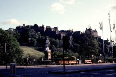
                                   The castle from the street below


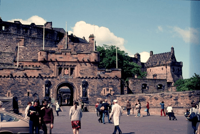
                                    Main Gate to the Castle
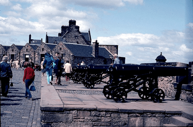
 

                                   Battlements


Palace Holyrood,


St. Giles Cathedral.


                                  Credit Google Search


We were fascinated by it all. We were impressed to find a soldiers dog cemetery on the grounds.


While Fred’s ancestral family is from near Perth (actually Forgendenny in Perthshire), I’ve recently discovered that my ancestral family is from the southwest part of Scotland, Galloway. I didn’t know that then, or we might have made a special trip to that part of Scotland.

After the bus tour, we got in our car and did a driving trip around. We left Edinburgh and drove by the Firth of Forth bridges to Stirling. From Google search I found:

Stirling is a city in central Scotland. At the heart of its old town, medieval Stirling Castle is on a craggy volcanic rock. On the Abbey Craig outcrop, the National Wallace Monument is a 19th-century tower. It overlooks the site of the 1297 Battle of Stirling Bridge, where William Wallace defeated the English. The Battle of Bannockburn Experience has interactive 3D displays on the history of the 1314 conflict.


Here’s a picture of the Stirling Castle:


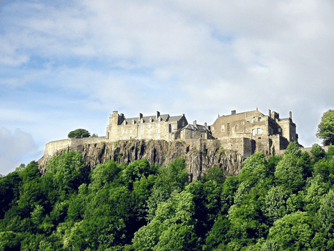
                          Stirling Castle – Lt.Wikipedia.org – Google search


We drove through Thornhill. From Google Search, I found:

Thornhill lies on the main A76 road from Dumfries to Kilmarnock as it follows Nithsdale north through the Southern Uplands. Its broad streets meet at a small roundabout on which you find the focal point of the village, the Mercat Cross [Scot for Market Cross].

The origins of Thornhill might date as far back as the Romans, who built a road through Nithsdale and a fort a little to the north at Carronbridge. By the 1600s there was an established settlement here, complete with a mill, though a wooden bridge over the River Nith built in the 1400s to provide a route to the west had already been lost in a flood.

I also found that there is a monument there to the explorer Joseph Thomson (after whom the Thomson’s Gazelle is named).

From Thornhill, we drove through the towns of Aberfoyle, Dryman, Balloch (where there is a castle situated at the southern tip of Loch Lomand), and Jamestown (which is rapidly becoming part of Balloch). Unfortunately, we apparently didn’t take any pictures of these towns.

We had wanted to see Loch Lomond, and we did, stopping only to take a few pictures.


~~~~~~~~~~To Be Continued~~~~~~~~~~

Circuitous Travel~Part 3

20 Aug

SUNDAY MEMORIES

Judy Wills


CIRCUITOUS TRAVEL – PART 3 continued

And so we left Edinburgh, went through Queensferry


Credit Google Search

to go over the Forth Bridge which goes over The Firth of Forth, an estuary of several Scottish rivers, and on to Dunfermline. Here are a few pictures we took of the Forth Bridge (for trains),


the bridge for trains and cars,


and the bridge for cars.

Again, from Wikipedia I gleaned: Dunfermline – The town was first recorded in the 11th century, with the marriage of Malcolm III, King of Scotland, and Saint Margaret at the church in Dunfermline. As his Queen consort, Margaret established a new church dedicated to the Holy Trinity, which evolved into an Abbey under their son, David I in 1128. Following the burial of Alexander I in 1160, the abbey graveyard confirmed its status as the burial place of Scotland’s kings and queens up to and including Robert The Bruce in 1329.


We found it to be a fascinating place to see. The ruins are beautiful, as is the current church, which is still in use.


The Church yard


Abbey & Palace – credit BikELove


Abbey & Palace – credit Historic Environment Scotland


Credit Google Search and TripAdvisor

From Dunfermline, we drove to Falkland Palace and Garden. Here are a few pictures we took there.


Palace entrance


Falkland Palace


From the Falkland Palace website, I found: Falkland was the country retreat of the Stewart kings and queens of Scotland, located within easy reach of Edinburgh, yet far enough distant to provide a welcome escape. Here the royal court could indulge in hawking and hunting, plus more genteel recreations like archery. Falkland boasts the oldest real (or ‘royal’) tennis court in the world, built in 1539 for James V.

The Falkland Gardens are quite beautiful, but are relatively new, being laid out in 1947.

From Falkland Palace and Garden, we finally arrived in St. Andrews on the coast.


After wandering around the golf course and the original golf club house, we purchased some goodies for ourselves as mementoes. We purchased a cashmere scarf; I purchased some Gunn Clan pins (Fred is a direct descendent of the Gunn Clan);


Credit Google Search


Fred purchased a Gunn Clan tie, which he still wears proudly. Here is a swatch of the Gunn Clan tartan. We think it is quite beautiful.


We were told there, that when a Scot female marries, she is not allowed to wear her husband’s tartan. She is always associated with her father’s tartan. Interesting.

We returned to Edinburgh, where we walked around the town a bit and shopped, as well. I purchased a Gunn Clan book; a Gunn Clan pin and necklace; and one meter of the Gunn Clan tartan. I intended to make some garment for our daughters. I’m ashamed to say that I didn’t get that done until this past Christmas. I made a long scarf for each of them, with self fringe. They are delighted with it.

Also in all of this shopping – especially for the tartan, I discovered that I have a family tartan, as well. It is the Colquhoun Clan – very similar to our American word/name of Calhoun. The tartan is very similar to the Gunn tartan, with similar colors. I think it’s pretty, as well.


~~~~~~~~~~To Be Continued~~~~~~~~~~

Florida Travel~Blowing Rocks Preserve

1 Aug

A Life to Live

Melody Hendrix


Blowing Rocks Preserve    574 S Beach Rd, Hobe Sound, FL 33455

Blowing Rocks Preserve is an environmental preserve on Jupiter Island in Hobe Sound, Martin County, Florida. It is owned by The Nature Conservancy. It contains the largest Anastasia limestone outcropping on the state’s east coast.


The dark, jagged rocks are a specific type of sedimentary rock called Anastasia limestone.


Scientists disagree on exactly how far inland the limestone extends, exactly when it was formed (most likely around 120,000 years ago, in the Pleistocene Age) and whether it was formed by a single event or by multiple changes in sea level.

A few things scientists can agree on:

Anastasia limestone extends along Florida’s coast from St. Augustine to Boca Raton, and

Blowing Rocks Preserve harbors the largest outcropping on the U.S. Atlantic Coast.

The exposed rock at the preserve is unusual, not because Anastasia limestone is particularly rare, but because it is commonly found either underground or underwater.


Also known as coquina, from the Spanish for cockleshell, Anastasia limestone is composed primarily of shell and coral fragments, fossils and sand. Small fossils are clearly visible in the rock faces, most commonly the shells of small clams and oysters or pieces of a large snail called Busycon.

Why is so much of the limestone above ground at Blowing Rocks? No one knows. The land here might have once been part of an exposed sand ridge or the top of a reef, or for some other reason higher than surrounding areas.

At their height in winter, the Blowing Rocks are worth a visit in every season. The wind- and wave-carved limestone forms chimneys and shelves, burrows, blow holes and rocky pools. These offer great opportunities for exploration and imagination, as well as a rare window into Florida’s natural history.


You may want to check the tide schedule for Jupiter Island.

When the tide is high the water shoots up holes in the rocks. It can be a spectacular sight.


It is also beautiful to visit at low tide when you can walk the beach and explore the rocks and caves.


There are some great places in this area to enjoy. One of the places I liked was

Coral Cove Park    19450 County Hwy 707, Tequesta, FL 33469


This beach also had rocks at low tide, but it also had a nice sandy swimming beach. Coral Cove Park is a waterfront park located in Tequesta, Florida, right outside the city of Jupiter at 19450 State Road 707, Tequesta, FL. Excellent park with beach access. Facility has restrooms and a shower to wash the salt and sand off after a day at the beach. Lots of parking.

​​​​​Carlin Park 400 S. S.R. A1A Jupiter, Florida was another very nice beach park.

Carlin Park is a great place to spend the day. It has many amenities including a beach that has lifeguards. There are pavilions for picnics, a nice small restaurant with good food, a playground for the children. I have been taking my family there for years and it is always well maintained; a very pleasant place to bring the family.

There is a beautiful lighthouse and museum that is a must.

Jupiter Lighthouse and Museum

If you love to beach hop, take a beach tour on your way back home. Start from Jupiter Inlet Lighthouse A1A to S. Beach Rd and follow it north to SE Bridge Rd back to I-95, stopping at all the beautiful beach accesses and explore each beach along the way. Most of them are uncrowded quiet beaches.


Please visit next week as we leave Florida and go to Savannah and Tybee Island Georgia.


I am retired and enjoying life. My hobbies are my 5 grandchildren, son and daughter, and my loving husband. I am a photographer and extreme nature lover. I love spending time in my garden or in the wilderness connected to God my Creator.
Melody

Florida Travel~Sanibel

18 Jul

A Time to Live

Melody Hendrix


Oh Sanibel. I love this place. The white sand beaches and beautiful clear water are spectacular.


We so enjoyed our stay there.


https://www.tripadvisor.com/Attractions-g34481-Activities-Captiva_Island_Florida.html

Sanibel is a city on Sanibel Island in southwest Florida. One of the features on the island is a beach with a fishing pier called Lighthouse Beach.


The Causeway Beaches are a water-sports hub and have picnic facilities.

J.N. “Ding” Darling National Wildlife Refuge covers about half of the island. Popular for wildlife enthusiast and bird watching.

The Sanibel Island Light or Point Ybel Light was one of the first lighthouses on Florida’s Gulf coast. The towering, 19th-century Sanibel Lighthouse and a boardwalk winds through marshes.


The light, 98-foot above sea level, on an iron skeleton tower was first lit on August 20, 1884 and has a central spiral staircase beginning about 10 feet above the ground. It is located on the eastern tip of Sanibel Island, and was built to mark the entrance to San Carlos Bay for ships calling at the port of Punta Rassa, across San Carlos Bay from Sanibel Island.


The lighthouse was placed on the National Register of Historic Places in 1974.


The northern part of Sanibel is a little quaint town of Captiva. Different than the lower part. Colorful shops and restaurants. The beaches seem to be even better.


Below is a list of things to do.

https://www.tripadvisor.com/Attractions-g34481-Activities-Captiva_Island_Florida.html

One of my favorite events was the Sanibel Thriller boat ride. If you love dolphins you will be delighted to see them riding the boats waves and jumping out of the water. It’s a bit of trouble to get there, but so worth it.


Join me next week for a trip to the Keys.


I am retired and enjoying life. My hobbies are my 5 grandchildren, son and daughter, and my loving husband. I am a photographer and extreme nature lover. I love spending time in my garden or in the wilderness connected to God my Creator.
Melody

Florida Travel~Washington Oaks Gardens State Park

19 Jun

A Time to LIve

Melody Hendrix


Washington Oaks Gardens State Park is a Florida State Park located near Palm Coast, Florida, along A1A just a short distance north of Ponce Inlet .


 http://www.washingtonoaks.org/

Washington Oaks Gardens State Park

6400 N. Oceanshore Blvd.

Palm Coast, Florida 32137

(386) 446-6780


The park is most famous for its formal gardens.


It also preserves the original habitat of a northeast Florida barrier island.


The park has such amenities as beaches (on both the Matanzas River and Atlantic Ocean), bicycling, fishing, hiking, picnicking areas and wildlife viewing. The original residence has been converted into a visitor center with interpretive exhibits.

The Park’s eastern boundary holds  outcroppings of coquina rock , creating a picturesque boulder-strewn beach. It is full of swirling, sculptured coquina rocks piled along the beach, some sporting circular holes, others forming bowls that create tide pools for snails and anemones.

This unusual beach in Florida is a well-kept secret, hoarded by the locals who refer to it as “The Rocks”.


One quick stop just before Matanzas is Marineland. Hurricanes Floyd and Irene in 1999 forced the park to close for two months. In 2003, all of the park buildings west of Highway A1A were demolished leaving only the original structures along the Atlantic Ocean. In 2004, the park closed completely for renovations, and reopened on March 4, 2006. In January 2011, Marineland was sold again and is currently being operated as a subsidiary of Georgia Aquarium. The facility, now named Marineland Dolphin Adventure, offers several dolphins encounters, educational programs, and conducts research to help care for marine life in human care and in the wild.

The park has a nice boardwalk and restrooms. The beach is also strewn with outcroppings that appear at low tide.


A little farther north on A1A is Matanzas Inlet. 

It is a channel in Florida between barrier islands connecting the Atlantic Ocean and the south end of the Matanzas River. The inlet is not stabilized by jetties, and thus is subject to shifting.


The above picture shows the inlet at low tide and across it is the Matanzas Monument location. It was designated a United States National Monument on October 15, 1924.

Below is a link to the forts history

https://www.nps.gov/foma/learn/historyculture/the_massacre.htm

Hurricane Matthew caused damage. Below, shows (Sept. 6, 2014) and after (Oct. 13, 2016)  the damage hurricane Matthew did to this area. The storm cut a new inlet between the Atlantic Ocean and the Matanzas River near St. Augustine, Florida, stripping away a 12-foot dune and carrying sand into the estuary and altered a part of the northeast Florida coastline.


Matanzas Inlet is still a beautiful place. One of the treasures that draws me to this place is the sand. With the changing of tides and blending of the swift moving bodies of water, the patterns in the sand are truly master pieces that are sculpted everyday. Tide pools trap interesting creatures to explore. Lots of birds dine on the abundant food available. This area is loved by fishermen.


The rocks that add to the unusual look for a Florida beah appear and disappear with the tide.


You must be aware of the tides on the south side of the inlet. You can be trapped by incoming tides and forced to exit through private property.


There is beauty in all sides of the bridge. The inlet side, and the beach side. There is also a long boardwalk and parking on both sides.

If you love beach walks, photography, birding,  beaching, hiking or just exploring, this would be an enjoyable little trip.

Please join me next week on our last northern stop along A1A to St Augustine before we head west to the Suwannee River and some visit some springs.


I am retired and enjoying life. My hobbies are my 5 grandchildren, son and daughter, and my loving husband. I am a photographer and extreme nature lover. I love spending time in my garden or in the wilderness connected to God my Creator.
Melody

Peru and the Amazon River~The Final Episode

23 May

A Life to Live

Melody Hendrix

I hope you have enjoyed sharing this journey with Melody on the Amazon River. I certainly have-Onisha

Sights of the Rainforest

For the last post of the Amazon series, I have included some random sights of the rainforest and land excursions and a little more information about this extrodinary place. Unfortunately, I only have a handful of the wildlife pictures here. We could only view from afar unless they were domesticated.

Behaviourally, Oropendolas are very interesting birds. They make long hanging nests which may provide protection from snakes.


The birds feel their hanging nests aren’t enough to protect their young, as they often nest around highly dangerous wasps. The wasps offer protection from parasitic species such as cowbirds, which lay their eggs in the nests of others. These parasitic birds often kill the nestlings and force the host-bird to care for their young.


Below, the Hoatzin (stink bird) is an herbivore, eating leaves and fruits, and has an unusual digestive system with an enlarged crop used for fermentation of vegetable matter.The alternative name of “stinkbird” is derived from the bird’s foul odour, which is caused by the fermentation of food in its digestive system.


This is a noisy species, with a variety of hoarse calls, including groans, croaks, hisses and grunts. These calls are often associated with body movements, such as wing spreading.


Water buffalo have been introduced, especially in the flood plains because they can thrive in a wet environment where cattle cannot.

This buffalo was in the water but quickly approached  me to find out what that strange noise was coming from. It was the camera clicking. It was a little nerve racking, but I came out alive.

Below, many sloths were pointed out to us as we explored along the river by boat, but all were a distance away. There is one sloth hanging in this picture.

Sloths are actually lazy with very low metabolisms.


Sloths sleep from 15 to 18 hours each day! Some even stay in the same tree their entire life. They spend most of their lives upside down.

Sloths are amazing swimmers. They are known to sometimes simply let go from their tree branch and drop into water below for a quick swim. They can move three times faster in water than they can on land.

Capybaras.


A constant source of water is important to capybaras, who retreat into murky waters to escape from predators. People eat capybara meat and produce leather from their skin. We often saw them in the villages along the Amazon.

Back to Lima where we spent our first and last day, I walked around a bit to record some of the life in Lima. Quite a large city. This was our hotel view.


Using every bit of space possible, rooftop living is common.

The city was founded by the Spanish conquistador Francisco Pizarro on January 18, 1535. He called it ‘La Ciudad de los Reyes’ (the City of the Kings). It became the capital and most important city in the Spanish Viceroyalty of Peru. And after the Peruvian War of Independence, it became the capital of the Republic of Peru.


The buildings are adorned with great history and art.


Artisans line the streets with their talents.


I hope you enjoyed your trip to Peru and the Amazon. Thank you for visiting.


I am retired and enjoying life. My hobbies are my 5 grandchildren, son and daughter, and my loving husband. I am a photographer and extreme nature lover. I love spending time in my garden or in the wilderness connected to God my Creator.
Melody

Memories of New Mexico~Part 13

21 May

SUNDAY MEMORIES

Judy Wills


More random memories of New Mexico:


In previous musings, I’ve written about Sandia Crest, on the East side of Albuquerque.


Sandia mountains, East of Albuquerque


Albuquerque is in the “valley” between two sets of mountains. (Please revisit my post of February 15 2015 about The Crest) The Sandia’s, to the East, are the tallest, while the ones to the West, are more volcanic. There are essentially two ways to get to Sandia Crest: drive, or take the Tram. My post of February 15, 2015 tells more about the tramway.

Occasionally, on a family outing, we would drive from our house up to the Crest. As mentioned before, the Crest tops out at 10,678 feet above sea level. And since it is that high, it is COLD up there – even in the middle of summer!!


At the top, one will find the usual gift shop (tourist trap as we like to call them), but they have some delightful New Mexico items to purchase. Also at the top are several microwave towers, as well as observation stations. If one cares to look – especially during the daylight hours – the entirety of Albuquerque can be seen from any of those observation points – probably 100 miles! It truly is a magnificent view!

Driving up to the Crest was an adventure in itself. At the time I lived in Albuquerque, there was just a two-lane road going up, with a lot of twists and turns – we called them “bobby pin” turns, or hair pin turns. But I suppose that was the best way to build the road to make the grade up that tall mountain do-able. It’s been many years since we made the jaunt up, so I’m not sure how the road is, at this point.

After Fred and I married and moved away from New Mexico, my parents kept talking about this neat all-you-can-eat-fish/chicken restaurant on the way up to the Crest. It was called Bella Vista (beautiful view), and it did have a magnificent view. It was such a popular eatery, that they just kept expanding and expanding, until they could seat approximately 500 people! Busy place! And the food was terrific! Of course, it was all fried fish or chicken, but that was okay back in that day. Unfortunately, the original owners of the restaurant either died or retired, and their children took over. The children turned it into a sports bar – which didn’t go over very well with the usual clientele, and the business folded. We were sorry to see it go.


Credit Google Search


As for driving up/down the mountain, I remember the time after my Mother died. Fred and I had flown to Albuquerque for the funeral, along with my brother, Bill and his wife, DiVoran. Our oldest daughter, Karen, and her husband, Brian, had made a driving trip from South Carolina, as well. We wanted to introduce Karen and Brian to Bella Vista, so we all made one “last” supper visit to Bella Vista, before heading back to our respective homes. By the time we had finished eating, it was beginning to get dark outside. Fred was driving the four of us, with Karen and Brian following us in their car, down the mountain. Fred, not being too familiar with the rental car, was trying to find the head light switch, while driving. At one point, he either hit or turned a button, and all the car lights went out. We all said “NO!” and he turned the switch back on quickly. Karen later told us that they both yelled “NO!” at the same time! There was just too much darkness to be driving down that mountain without head lights!

~~~~~~~~~~To Be Continued~~~~~~~~~~

Peru and the Amazon River Part 6

16 May

A Time to Live

Melody Hendrix

Nazca Lines

For our next adventure and one I have been looking forward to is a flight over the Nazca lines. We began at the Lima (capital of Peru) airport where we boarded a small but comfortable plane. We were going to hop to another airport where they would take us to see the lines.


It was an amazing sight already flying over the Andes mountains. For the most part just a bare landscape of sand and rock . There were structures that made you wonder, possibly to store or extract water from underground.

Arriving at our next airport was a shocker. All I could see was mountians of sand and an extreme primitive control tower that looked like a tropical hut.


Inside the airport however was a beautiful place to relax, eat and even see some wildlife. There was a sacred condor  (Kuntur).


The Condor teaches the ability of fly and freedom. It is one of the most sacred animals because it lives on the heights and rules the skies, like the master of the wind, the clouds and the sky.

They soon called us to board the plane. Oh dear….. I had a feeling this might be a little rough. It was a tight fit in a warm plane, but we were still excited about what we were about to see.


We arrived and the pilot wanted to make sure we could all see each of the lines by lowering one wing, then the other. The motion soon got to me. I was able to click only a couple of pictures.


There were several trapezoids. Some believe they are landing strips for aliens, others believe they are roads that lead to gatherings of water rituals.

There are a few different birds that look similar. This one is believed to be a condor.

This one is called the owl man. Some believe it is an astronaut.

And some believe it to be a fisherman holding a fish and net.

This graph I found online shows many of the geoglyphs and what they are.


Some 700 geoglyphs (Nazca lines) are thought to have been drawn by the ancient Nazca people who flourished from around 100 BC to 800 AD. The earliest lines, created with piled up stones, date as far back as 500 BC.

Many of the images also appeared on pottery and textiles of the region.

Other drawings represent flowers, plants, and trees.

Archaeological surveys have found wooden stakes in the ground at the end of some lines, which support the theory the ancient people used simple tools and surveying equipment to construct the lines.

Most of the lines are formed by a shallow trench with a depth of between four inches and six inches, made by removing the reddish-brown iron oxide-coated pebbles that cover the surface of the Nazca desert and exposing the light-coloured earth beneath.

The largest geoglyph is a 935ft-long of a pelican.

The purpose of the lines continues to elude researchers and remains a matter of conjecture. Ancient Nazca culture was prehistoric, which means they left no written records.

One idea is that they are linked to the heavens with some of the lines representing constellations in the night sky. Another idea is that the lines play a role in pilgrimage, with one walking across them to reach a sacred place such as Cahuachi and its adobe pyramids. Yet another idea is that the lines are connected with water, something vital to life yet hard to get in the desert, and may have played a part in water-based rituals.

Anthony Aveni, a former National Geographic grantee, agrees, “Our discoveries clearly showed that the straight lines and trapezoids are related to water … but not used to find water, but rather used in connection with rituals.”

“The rituals were likely involved with the ancient need to propitiate or pay a debt to the gods…probably to plead for water.”

Anthropologists, archaeologists, and astronomers have all studied the lines, but have not found conclusive evidence for any of the theories.

Please join me next week for some wildlife and landscapes of the Amazon. Hanging Oropendola bird nests below.

A 2016 Dawn Patrol Rendezvous Trip~Part 14

5 Apr

A Slice of Life

 Bill Lites


Day 14 (Wednesday Oct.12, 2016)
Today was more or less a free day, since I had visited some of the museums around Columbus, scheduled for today, on the first day of this trip. I started

with the hope that I could visit the Waco Aircraft Collection of Anthony M. Morozowsky, there in Zanesville, before I headed toward Columbus. A month before this trip, I sent Mr. Morozowsky a letter requesting a visit to his collection. However, I never did receive an answer and the only thing I had to go on was the address on the FAA Registry, for his 30+ aircraft. When Greta informed me that we had arrived at our destination, I was disappointed that it turned out to be nothing more than a vacant lot and a couple of rusty broken down vehicles.


So I headed west on I-70, to visit the Historical Aircraft Squadron located in Carroll, Ohio. This was a small one hanger museum with six nicely restored airplanes, and a collection of retired ex-military volunteers sitting around the coffee machine sharing war stories. What a great bunch of guys!


Next on the list, was a visit to the Motorcycle Hall of Fame Museum, located a few miles north in Pickerington, Ohio. I have visited so many museums, in the last two weeks that it was sometimes hard to remember which ones I had already visited, until I actually pulled into the parking lot. This was one of the museums I had visited earlier. That’s OK, since I was headed that direction anyway.


Just a few miles west, I went to visit the Bob McDorman Automotive Museum, located in Canal Winchester, Ohio. This museum was closed when I tried to visit it on day 1 of this trip (even though the sign out front said “Open Wed-Sat 1-5”). As it turned out, it was closed again today (Same sign was outside; Go Figure), and I missed out seeing Bob’s fine collection.


Now it was on down the road, to visit the Motts Military Museum located in Groveport, Ohio. To say this was the most extensive display, of military memorabilia that I have ever seen in a museum, would be an understatement. There were two large wings to the museum absolutely chocked full, from floor to ceiling, of memorabilia on both walls covering the U.S. military services dating from the Civil War through current times. The museum also had a very nice display of restored military vehicles and weapons displayed outside.


Now I headed into Columbus to visit the Ohio Village & Museum, at the Ohio History Center. The portion of the Center that housed the museum was a massive edifice, and would take the average person hours to go through it. Once I got a look at a museum layout map, at the visitor’s desk, I decided not to spend the time there and move on to the next museum.


The Camp Chase Site and Confederate Cemetery, located some four miles west of downtown Columbus, was surrounded by a high brick wall and I almost missed it. Wikipedia informed me that the camp was established in 1861, during the Civil War, as a staging and training base, and included a Confederate prisoner-of-war camp. Named for Salmon P. Chase, Abraham Lincoln’s Secretary of the Treasury, the site was closed in 1865 and the buildings were dismantled. The cemetery arch was erected as a memorial, to the many Confederate soldiers who were imprisoned at the camp, and to the 2200 that died there before the war ended.


The Ohio Railway Museum, located in Worthington, Ohio, some 12 miles north of Columbus, was the last museum on the list for this trip. As it turned out this was a very small museum, consisting of local railroad memorabilia and some very weather-beaten rolling stock.


Since it was still early afternoon, I headed for the motel, to get settled in and, so I could use their computer to print-out my boarding pass for my Southwest flight tomorrow. Because the Enterprise Rental Car office, where I rented my car, did not provide transportation to the airport, I had to come up with some way to get there on my own.


There was the taxi option, or possibly the Uber option. I liked the sound of the Uber option better, and spent quite a bit of time registering an account with them. I just hoped I would be able to use them tomorrow. We’ll just have to wait and see how that works out.


Dinner tonight was another delicious (leftover) dinner of Grilled Rainbow Trout with corn, green beans and one of their Cracker Barrel famous buttermilk biscuits with butter and honey for dessert. Yuuum!! Again.


—–To Be Continued—–

A 2016 Dawn Patrol Rendezvous Trip~Part 7

15 Feb

A Slice of Life

 Bill Lites

Bill Small Red Plane


Day 7 (Wednesday, Oct.5, 2016)
I took my time getting ready this morning because my first stop today was to visit the Grissom Air Museum (located only about 10 miles north of the motel) and just south of Peru, IN. Since they didn’t open until 10 o’clock, I slept in and had a leisurely breakfast. The museum had a small memorabilia area with some cockpit simulators and a nice collection of static displayed aircraft outdoors.


1


Next on the list was the Kersting World of Motorcycles Museum, located 4 miles south of North Judson in Winamac, IN. This museum turned out to be situated in the middle of cornfields on all sides, and Greta and I had a difficult time locating it. I was given a personal guided tour of the museum, by the 80-year old founder and owner, Jim Kersting. Jim told me that he built his first motorcycle at age 12, and that he called it the Simpletag (See the museum’s website for the fascinating story of how the motorcycle got its name).


2


The first motorcycle of Jim’s collection was a 1931 Indian 4-cycinder, which he got at a farm auction, and his collection has been growing ever since. Jim told me the story behind many of his various 100+ machines in the museum, and was especially proud of the ones he raced at Daytona, Florida when he was younger. He had some great stories to tell of his adventures.


3


Next, just up the road a ways, I had planned to visit the Hoosier Valley Railroad Museum located in North Judson, IN. However, it turned out that the museum is only open on Saturdays, so the best I could do was to stop and take a picture of the station.


4


My next stop turned out to be the farthest west I would go on this trip. The plan was to visit the Indiana Aviation Museum, located adjacent to the Porter County Regional Airport in Valparaiso, IN. When I couldn’t find the museum, I stopped at the airport and talked to a friendly young man. He informed me that the museum had evidently sold all their airplanes, and closed the museum a year or so ago. They still had an Internet website listing, so I was surprised to learn of the museum’s closing.


5


Even after getting off to a slow start this morning, I was still running a little ahead of schedule by now, so I headed northeast a few miles to visit the Old Lighthouse Museum, located in Michigan City, IN. This was a very small lighthouse building that has been converted into a museum. The ground floor of the building is made up of mostly local lighthouse memorabilia, and I was offered the opportunity to view the yacht harbor from the top of the lighthouse structure. I declined this offer, as I’m sure my knees would have given out before I got to the top. The elderly museum curators understood completely.


6


Next, I headed southeast to visit the La Porte Historical Society Museum, located in La Porte, IN. This was a fabulous multi-level museum, containing a huge collection of local historical memorabilia of all sorts. This part of the museum included fully furnished living room, dining room, and kitchen representations for the 1920s, 1930s, 1940s, and 1950s.


7


The Door Prairie Auto Museum, which once was a museum by itself, has now been incorporated into the La Porte Historical Society Museum, and takes up the entire second floor of the building. This automobile museum has some of the most unusual examples of the early American auto industry, and each automobile has been beautifully restored for museum display and public auto shows.


8


By now it was time to head for the motel, for a marvelous meal of leftover Cracker Barrel grilled catfish with green greens, corn, and one of their famous hot buttery biscuits and honey for dessert. One of my favorite meals.


9


—–To Be Continued—–